Ethical statement
The Ethical Committee of the Zoological Institute (RAS #2015-01-14) and Kaliningrad Regional Agency for Protection, Reproduction and Use of Animal World and Forests approved sampling procedures and experimental manipulations, and permitted the catching and tagging of cuckoos. This study was carried out in accordance with Guidelines to the use of wild birds in research of the Ornithological Council43.The common cuckoo is not a protected species and it is not considered threatened or endangered.
Experimental animals, tagging and displacement
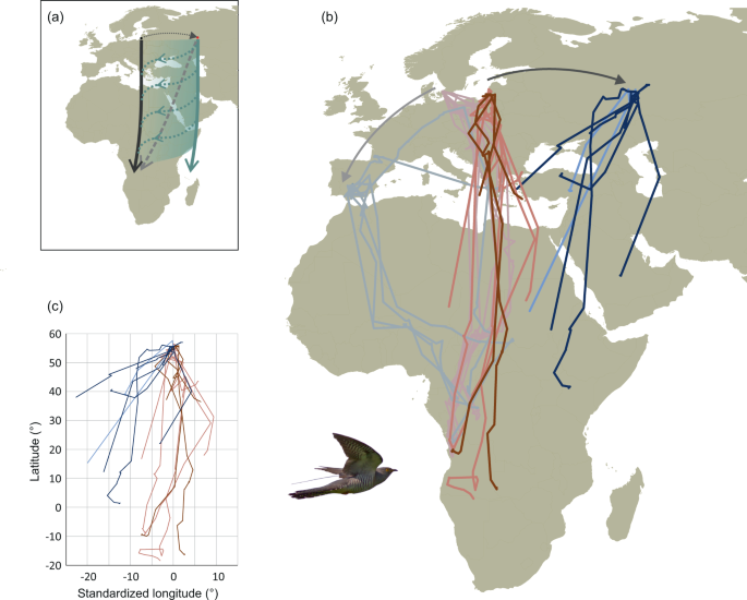
Adult and juvenile cuckoos used for the study were caught in the Kaliningrad Region shortly after initiation of autumn migration during late July – August 2015-2018. Individual migration routes were tracked using satellite telemetry and individuals were either controls (tagged and released close to trapping site) or displaced (tagged and displaced in groups 1,800 km eastward to Kazan, Tatarstan).
Cuckoos were trapped at two sites: the Biological Station Rybachy (55° 9’ 13” N, 20° 51’ 29” E) and the Fringilla Field Station (55° 5’ 18” N, 20° 44’ 3” E). Two large Heligoland traps at the Fringilla station as well as mist-nests at the two stations were used for trapping. Playback of cuckoo song and calls was widely used to attract birds.
To treat both control and experimental birds equally, all birds were kept in aviaries after trapping for 1 to 22 days. They were provisioned with mealworms and water ad libitum until tagging and release. During this time, the birds’ behaviour and weight changes were monitored. Birds with high body mass (minimum >100 g) and good condition were tagged and released, or kept for planned displacement events if they had not been kept in captivity for too long (> 1 week). Control birds were released during the period both before and after displacements.
We fitted satellite transmitters on 27 juvenile and 18 adult common cuckoos (see Supplementary Table S1-2 for deployment details). Tags were fitted with a backpack harness of 2 mm ø braided nylon cord. The juvenile harness size was the same as the one used in adults to account for further body growth44. Cuckoos were tagged just before release (control birds), or one or two days before (displaced birds).
The displaced group consisted of 15 juveniles and 7 adults translocated to Kazan in 2015, 2016 and 2018. They were transported by commercial airline in pet carriers and released into a natural, wooded habitat in daylight conditions as soon as possible after arrival (release site 55° 51’ 18” N, 48° 48’ 18” E and 55° 39’ 22” N, 49° 2’ 13” E, respectively). The control group consisted of 12 juveniles and 11 adults. Apart from the early movement of two juveniles displaced to Kazan that moved more than 100 km within four days, we found no general difference between control and displaced birds in departure timing after release (Difference in days after first position when crossing 500 km distance: p = 0.154, 1,000 km distance: p = 0.920; t-tests).
Tracking
The tags used for this study transmitted location information via satellites. Two models of transmitting tags were used to obtain spatial data in this study: Platform Terminal Transmitters (PTTs) 5 g solar PTT-100s (Microwave Telemetry Inc., Maryland, USA) and 3.4 g or 3.7 g PinPoint GPS ARGOS Tags 75 (LOTEK, Newmarket, Canada; tag mass depended on antenna specifications).
Location estimates were obtained from PTTs by interpreting the Doppler effect of transmissions from the tags to the Argos Satellite system. Position quality and accuracy is determined (where possible) by the number and duration of transmissions (estimated error classes 0: >1,500 m; 1: 500–1,500 m; 2: 250–500 m; 3: <250 m (45). The tags had a solar cell and the temporal schedule was 10 hours transmission followed by 48 hours off, for as long there was sufficient power.
The PinPoint tags provide GPS positions acquired at scheduled intervals, compressed and transmitted via the Argos system. The tags are scheduled in advance and limited by internal battery capacity (determined by the GPS acquisition time and transmission of data to the Argos system). In 2015, tags were programmed to obtain positions regularly on a short schedule and transmit data on a predefined date (estimable to a date prior to the Sahara crossing), or for a long schedule where positions were attempted until transmission which was determined by a critical battery voltage. In 2017, tags were equipped with Argos satellite pass prediction software by which the tag only transmitted data when a satellite was within range, thus substantially improving power efficiency and enabling regular transmission of data throughout the migration period. All transmission data include time stamps and satellite ID.
From the PinPoint tags, GPS position data were transmitted via the ARGOS satellite system and processed with LOTEK software; failed positions were excluded. Doppler positions can also be obtained from transmitting PinPoint tags but only a few of these were received.
In cases where an Argos transmission occurred but no Doppler position could be estimated, an estimate and error radii was calculated from satellite pass data by CLS. Where a PinPoint tag had acquired a concurrent GPS position this was used in preference to the ARGOS estimate.
After rejecting class Z estimates, we used the highest quality position from each transmission cycle closest to noon.
Data analyses
Of the 27 tagged juveniles, we considered the 12 individuals that were tracked for more than 500 km/crossed south of 50°N to have started migration (Table 1). Initial movements appeared to be slightly further westward in the first year but the bearings after crossing 100 km were not significantly different from the other years, and thus in the analyses we considered results from all years together. In adults, 9 of 18 started migration.
We used the highest quality position for every duty cycle obtained from ARGOS/CLS44. Several birds moved back and forth for some time after release with no consistent direction of movement, and we considered that they started migration when consistent directions were observed.
We investigated the spatiotemporal pattern of responses by grouping individuals’ locations according to when they had passed certain distances. However, the sampling schedule did not allow detailed analyses of timing of responses. We compared bearings and timings after crossing 500 km (n = 13) and 1,000 km (n = 19) from the release areas because for shorter intervals there were not enough locations for meaningful comparisons (only up to a maximum of 7 in 100 km intervals). The directedness of sample orientations for the individuals of a group was tested with the Rayleigh test. Differences in sample orientations were tested with Watson-Williams tests. We used t-tests on day of the year of crossing 500 km and 1,000 km as well as reaching endpoints to compare the timing of migration between controls and displaced and between adult and juveniles.
Because of the distance to the wintering grounds, even large distances at the latitude of the wintering grounds result in potentially relatively small differences in bearings. Thus, in addition to comparing bearings to endpoints (last position, see Supplementary Table S2 for details) using a Watson-Williams test, we tested for evidence of navigation in young birds by comparing the westward longitudinal displacement of endpoints in displaced versus controls. We treated longitude data as linear and compared groups with a t-test. This was justified as less than 10% of the full circle of longitudes were traversed and the Watson-Williams test based on longitudes reported the same result (F1,10 = 6.701, p = 0.027 for a difference between controls and displaced). In an ANOVA including both age and displacement effects together, displacement was significant but age was not (p = 0.07) potentially because of small sample size.
To test for displaced individuals compensating for the displacements, we compared with tracks simulated under the assumption that control birds follow a clock-and-compass strategy (vector orientation). Outliers (i.e. significantly deviating longitudinally), were considered compensating if the deviation was in the direction of compensation (Fig. 4). In the young cuckoos, we identified 37 movements longer than 100 km that were used for simulations. Considering the longitudes and latitudes traversed in each of these as the result of a clock-and-compass step, we simulated tracks by adding from 1 to 15 randomly chosen longitudes/latidues from this set. For each total number of steps (1 to 15), we simulated 1,000 tracks, resulting in a total of 15,000 simulated endpoints for the test data.
We used R 3.3.246 for linear statistics and Oriana 3.047 for circular statistics and diagrams. MS Excel was used for simulations.
Source: Ecology - nature.com
