The database31 provides a comprehensive overview of the current knowledge of the fish species diversity and distribution in the Amazon Basin, with 21,500 sites (Fig. 1), 232,936 georeferenced occurrence records and 2,128 non-georeferenced records from 590 different sources combining literature, scientific collections, sampling campaigns and partner’s datasets. Some of the online biodiversity repositories (Table 1) showed some redundancies because often referring to the same collections. In this specific case, only one occurrence record was retained.
The main sources of the database are online biodiversity databases (56% of the occurrences), followed by locally hosted data from the scientific partners (Peru and Colombia), museums and universities from Brazil, Bolivia and Ecuador (38%), literature data (5% of the records) and data obtained during sampling campaigns by partners from Colombia, Peru and Brazil (1%). This represents 93 different collections from Scientific Institutions, 31 Partners references, 459 literature references and five AmazonFish expeditions.
The database includes information for 56 families, 514 genera and 2,406 native valid freshwater species, virtually half of the circa 4,760 total number of species known for the whole Neotropical biogeographic region5,6. Among these 2,406 species, 1,402 are found exclusively in the Amazon Basin (i.e. species appearing nowhere else on Earth; Amazonian endemic species) based on the global species distribution provided by Tedesco et al.5.
The lowland Amazon and its two main tributaries, the Negro and Madeira Rivers regroup the highest number of sites, occurrences and the highest diversity (Table 2), whereas less information is available for some small tributaries. At the sub-drainage grain, the density of sites presents an important spatial variability (Online-only Table 1 and Fig. 2). For instance, the Curuçá sub-drainage belonging to the Javari River, currently lacks information about its ichthyofauna. The ‘updates and limitations’ section below presents a more detailed overview of the spatial data gaps.
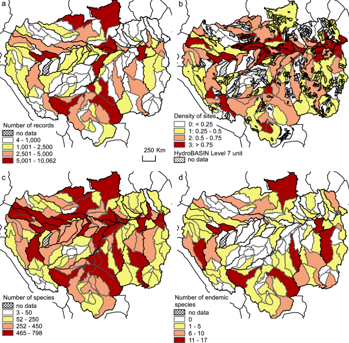
(a) Number of records, (b) density of sites (number of sites divided by the sub-drainage area and areas without information using the HydroBASINS Level7 spatial grain unit30), (c) total number of species and (d) number of endemic species (species present only in the Amazon Basin and only in the sub-drainage) for the 144 sub-drainage units.
The whole dataset is organised in three sub-sets31: a table of the species list by sub-drainage (‘GeneralDistribution’), a table of occurrence records with sources (‘CompleteDatabase’), and a shapefile of the 144 sub-drainages (‘SubDrainageShapefile’).
The first sub-set (‘GeneralDistribution’) contains the species list by sub-drainage with the taxonomic reference name (Family, Genus, Referent species valid scientific name and Author), the species status (‘native’ or ‘exotic’) and the occurrence species status (‘valid’, ‘to be verified’, ‘marine’). The corresponding table has nine columns (see Table 3).
The second sub-set (‘CompleteDatabase’) provides the geographic coordinates for the georeferenced sampling sites and the information source of each record. It is complemented with the original name of the species cited in the source (‘synonym’ or ‘typing error’) and those species with status ‘unknown name at present’. The detailed sources contain the source type of the data (‘Literature’, ‘Online Biodiversity Database’, ‘Partners Datasets’ and ‘AmazonFish Expedition’), the Biodiversity Repository source for the Online Biodiversity Database, the Scientific Institution Code and complete name, the GBIF Citation and DOI, the complete literature reference and the citation reference of the Partner dataset. Finally, the non-georeferenced occurrences are separated in three categories, ‘sub-drainage information’ (species occurrence information at the sub-drainage grain), ‘approximated coordinates’ (species occurrence information at river or reach scales) and ‘geographic error’ (the geographical coordinates of a site do not correspond to the geographical location given in the source). The corresponding table has 22 columns (see Table 3).
The third sub-set (‘SubDrainageShapefile’), corresponds to shapefile delineating all the sub-drainages and their corresponding geographic information and is organized in eight columns: (1) the major Amazon tributary name (MTRIB_NM), (2) the unique major Amazon tributary code (MTRIB_CD), (3) the unique sub-drainage name (SBD_NM), (4) the unique sub-drainage code (SBD_CD), (5) the surface area of the sub-drainage (AREA, in km2), (6) the main country where it belongs (COUNTRY), (7,8) the centroid longitude and latitude coordinates of the sub-drainage (CENT_X and CENT_Y).
The two table sub-sets (‘GeneralDistribution’ and ‘CompleteDatabase’) are in CSV format (columns separated by commas) and the shapefile sub-set (‘SubDrainageShapefile’) in ArcGis SHP format31. Both formats can be linked to the species occurrence table using the unique sub-drainage code or name to visualize and analyse species distribution using any adapted software (e.g. R or QGIS, http://qgis.osgeo.org). The sampling coordinates and shapefile are in the World Geodetic System 1984 (WGS84) datum and geographic coordinate system. The files of the database are in ‘CSV’ format (UTF-8 encoding, comma separator) and can be uploaded by most statistical software, spreadsheets or any other database management systems. The current version of the database can be retrieved from Figshare31, the AmazonFish website (https://www.amazon-fish.com/) and the Freshwater Biodiversity data portal (https://data.freshwaterbiodiversity.eu/).
Source: Ecology - nature.com
